cosmos.wikisort.org - Spacecraft
ATS-1 (Applications Technology Satellite 1) was the first experimental geostationary satellite, launched in 1966.[2][disputed (for: Syncom-3 was launched in 1964.) ] Though intended as a communications satellite rather than as a weather satellite, it carried the Spin Scan Cloud Camera developed by Verner E. Suomi and Robert Parent at the University of Wisconsin. After entering a orbit at 23,000 mi (37,000 km) above Earth, initially in orbit over Ecuador, it transmitted weather images from the Western Hemisphere, as well as other data, to ground stations, including well as video feeds for television broadcasting. It took one of the first pictures of the Earth's full-disk (the first from a geostationary orbit), on December 11, 1966.[3]
"For the first time," historians would note later, "rapid-imaging of nearly an entire hemisphere was possible. We could watch, fascinated, as storm systems developed and moved and were captured in a time series of images. Today such images are an indispensable part of weather analysis and forecasting." [4]
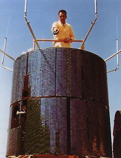 The ATS-1. | |
| Mission type | Weather Satellite |
|---|---|
| Operator | NASA |
| COSPAR ID | 1966-110A[1] |
| SATCAT no. | 02608 |
| Mission duration | 17 years |
| Spacecraft properties | |
| Bus | HS-306 |
| Manufacturer | Hughes Aircraft |
| Launch mass | 352 kilograms (776 lb) |
| Start of mission | |
| Launch date | December 7, 1966, 02:12:01 UTC |
| Rocket | Atlas SLV-3 Agena-D |
| Launch site | Cape Canaveral LC-12 |
| End of mission | |
| Last contact | April 1985 |
| Orbital parameters | |
| Reference system | Geocentric |
| Regime | GEO |
| Semi-major axis | 42,152.0 kilometres (26,192.0 mi) |
| Eccentricity | 0.00013 |
| Perigee altitude | 35,782.0 kilometres (22,233.9 mi) |
| Apogee altitude | 35,793.0 kilometres (22,240.7 mi) |
| Inclination | 3.6º |
| Period | 1,435.5 minutes |

It was the first satellite to use frequency-division multiple access which accepted multiple independent signals and downlinked them in a single carrier. The spacecraft measured 56 inches (1,400 mm) in diameter, 57 inches (1,400 mm) high and weighed 750 lb (340 kg).[5]
The ATS-1 satellite was used during the 1967 international television broadcast Our World, providing a link between the United States and Australia during the program.
The ATS-1 would remain operational for more than 18 years, until April, 1985.[6]
Features
This satellite was cylindrical, with a diameter of 142 cm (56 in) and a height of 135 cm (53 in); an additional 270 cm (110 in) in height was the engine cover. The surface was covered with solar panels, and the whole satellite was stabilized by rotation.
Instruments
A total of fifteen experiments were conducted during the mission:[7]
- Suprathermal Ion Detector
- Biaxial Fluxgate Magnetometer
- Omnidirectional Spectrometer
- Electron Spectrometer
- Particle Telescope
- Solar Cell Radiation Damage
- Thermal Coating Degradation
- Rate Range Beacon
- Spin-Scan Camera cloudcover
- Microwave communication transponder
- Communication VHF transponder
- Nutation sensor
- Resist-Jet Thruster
- Faraday Rotation
- Meteorological Data Relay System
References
- NASA – NSSDC – Spacecraft – Details
- Su-Yin Tan, Meteorological Satellite Systems (Springer Science & Business Media, 2013) p44
- "The 50th Anniversary of ATS-1". NOAA National Environmental Satellite, Data, and Information Service (NESDIS). 2016-12-06. Retrieved 2020-10-05.
- Stanley Q. Kidder and Thomas H. Vonder Haar, Satellite Meteorology: An Introduction (Gulf Professional Publishing, 1995) p7
- Missions – ATS – NASA Science
- Michel Capderou, Handbook of Satellite Orbits: From Kepler to GPS (Springer Science & Business, 2014) p279
- Experiment Search Results. NASA NSSDC Master Catalog. Retrieved 2016-22-05.
This article about one or more spacecraft of the United States is a stub. You can help Wikipedia by expanding it. |
На других языках
- [en] ATS-1
[es] ATS 1
ATS 1 (Applications Technology Satellite 1) fue un satélite artificial estadounidense dedicado a probar nuevas tecnologías. Fue lanzado el 7 de diciembre de 1966 y durante sus 18 años de vida el satélite probó técnicas de estabilización mediante giro, investigó el ambiente geoestacionario y realizó varios experimentos de comunicaciones. Mediante el experimento de VHF comprobó la posibilidad de actuar como enlace entre estaciones de tierra y aeronaves, demostró la obtención de datos meteorológicos desde terminales remotos y evaluó la posibilidad de utilizar señales VHF como método de navegación.Другой контент может иметь иную лицензию. Перед использованием материалов сайта WikiSort.org внимательно изучите правила лицензирования конкретных элементов наполнения сайта.
WikiSort.org - проект по пересортировке и дополнению контента Википедии