cosmos.wikisort.org - Spacecraft
Lunar Orbiter 5, the last of the Lunar Orbiter series, was designed to take additional Apollo and Surveyor landing site photography and to take broad survey images of unphotographed parts of the Moon's far side. It was also equipped to collect selenodetic, radiation intensity, and micrometeoroid impact data and was used to evaluate the Manned Space Flight Network tracking stations and Apollo Orbit Determination Program. The spacecraft was placed in a cislunar trajectory and on August 5, 1967 was injected into an elliptical near polar lunar orbit 194.5 by 6,023 kilometres (120.9 mi × 3,742.5 mi) with an inclination of 85 degrees and a period of 8 hours 30 minutes. On August 7 the perilune was lowered to 100 kilometers (62 mi), and on August 9 the orbit was lowered to a 99-by-1,499-kilometer (62 mi × 931 mi), 3 hour 11 minute period.
This article includes a list of references, related reading or external links, but its sources remain unclear because it lacks inline citations. (May 2020) |
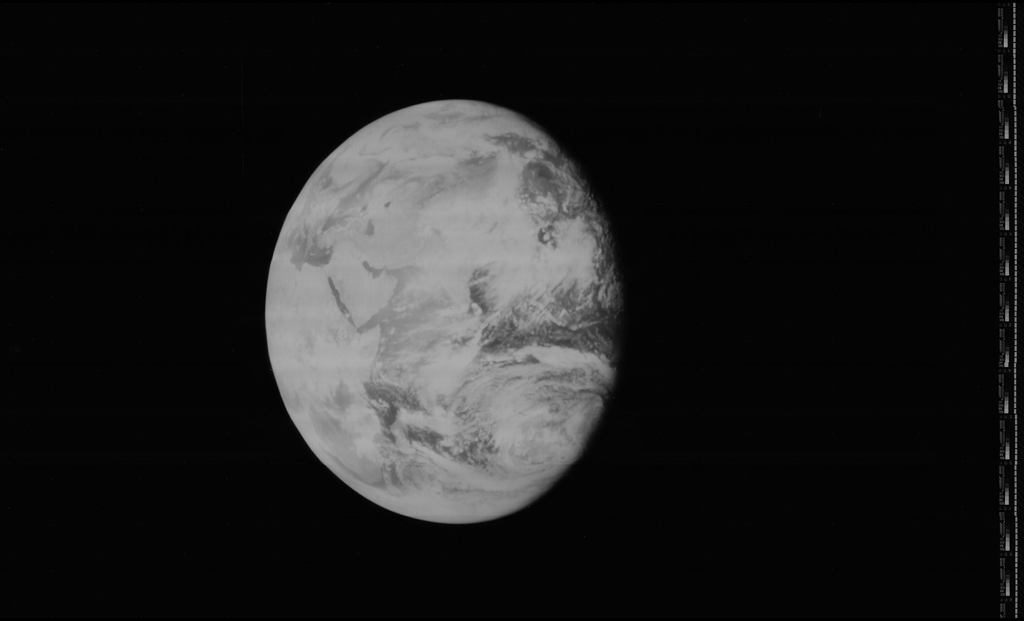 Image of the Earth taken by Lunar Orbiter 5, enhanced by LOIRP | |
| Mission type | Lunar orbiter |
|---|---|
| Operator | NASA |
| COSPAR ID | 1967-075A |
| SATCAT no. | 2907 |
| Mission duration | 183 days |
| Spacecraft properties | |
| Manufacturer | Langley Research Center |
| Launch mass | 385.6 kilograms (850 lb) |
| Start of mission | |
| Launch date | August 1, 1967, 22:32:00 UTC |
| Rocket | Atlas SLV-3 Agena-D |
| Launch site | Cape Canaveral LC-13 |
| End of mission | |
| Disposal | Deorbited |
| Decay date | January 31, 1968 |
| Orbital parameters | |
| Reference system | Selenocentric |
| Semi-major axis | 4,846.8 kilometers (3,011.7 mi) |
| Eccentricity | 0.26 |
| Periselene altitude | 194.5 kilometers (120.9 mi) |
| Aposelene altitude | 6,023 kilometers (3,743 mi) |
| Inclination | 85 degrees |
| Period | 510.08 minutes |
| Lunar orbiter | |
| Orbital insertion | August 5, 1967 |
| Impact site | 02.79°S 83.01°W |
| Orbits | 1,380 |
Lunar Orbiter program | |
The spacecraft acquired photographic data from August 6 to 18, 1967, and readout occurred until August 27, 1967. A total of 633 high resolution and 211 medium resolution frames at resolution down to 2 meters (6 ft 7 in) were acquired, bringing the cumulative photographic coverage by the five Lunar Orbiter craft to 99% of the Moon's surface. Accurate data were acquired from all other experiments throughout the mission. The spacecraft was tracked until it struck the lunar surface on command at 2.79 degrees S latitude, 83 degrees W longitude (selenographic coordinates) on January 31, 1968.
| Lunar Photographic Studies : | Evaluation of Apollo and Surveyor landing sites |
| Meteoroid Detectors : | Detection of micrometeoroids in the lunar environment |
| Caesium Iodide Dosimeters : | Radiation environment en route to and near the Moon |
| Selenodesy : | Gravitational field and physical properties of the Moon |
Features on the near side of the Moon that were photographic targets included Petavius, Hyginus, Messier, Tycho, Copernicus, Gassendi, Vitello, Mons Gruithuisen Gamma, Prinz, Aristarchus, Vallis Schroteri, Marius Hills, Montes Apenninus, Rimae Plato, Sinus Aestuum, Hipparchus, Rimae Sulpicius Gallus, Rimae Calippus, Censorinus, Dionysius, and the future landing site of Apollo 11.

See also
- Lunar Orbiter Image Recovery Project
- Exploration of the Moon
- Lunar Orbiter 1
- Lunar Orbiter 2
- Lunar Orbiter 3
- Lunar Orbiter 4
- List of artificial objects on the Moon
External links
- DESTINATION MOON: A history of the Lunar Orbiter Program (html version) 1976
- Lunar Orbiter Photo Gallery - Mission 5 at the Lunar and Planetary Institute
Lunar Orbiter program | ||
|---|---|---|
| Missions |  | |
| Related |
| |
NASA | |||||||
|---|---|---|---|---|---|---|---|
| Policy and history |
| ||||||
| Human spaceflight programs |
| ||||||
| Robotic programs |
| ||||||
| Individual featured missions (human and robotic) |
| ||||||
| Communications and navigation |
| ||||||
| NASA lists |
| ||||||
| NASA images and artwork |
| ||||||
| Related |
| ||||||
| |||||||
На других языках
[de] Lunar Orbiter 5
Lunar Orbiter 5 war die letzte Mondsonde des Lunar-Orbiter-Programms der US-amerikanischen Weltraumorganisation NASA. Mit dem Lunar Orbiter-Programm sollte der Mond fotografisch erfasst und kartografiert werden, um so Landeplätze für die Raumsonden des Surveyor-Programms sowie für die bemannte Mondlandung zu finden.- [en] Lunar Orbiter 5
[ru] Лунар орбитер-5
Лунар орбитер-5 (англ. Lunar Orbiter 5) — автоматический беспилотный космический аппарат НАСА, разработанный в рамках программы «Лунар орбитер», был запущен в 1967 году с целью картографирования поверхности Луны. Аппарат успешно выполнивший поставленные цели, став пятым и последним американским искусственным спутником Луны этой серии.Другой контент может иметь иную лицензию. Перед использованием материалов сайта WikiSort.org внимательно изучите правила лицензирования конкретных элементов наполнения сайта.
WikiSort.org - проект по пересортировке и дополнению контента Википедии