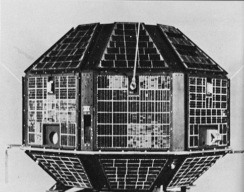
cosmos.wikisort.org - SpacecraftCartosat-2A is an Earth observation satellite in a Sun-synchronous orbit and the third of the Cartosat series of satellites. The satellite is the thirteenth satellite in the Indian Remote Sensing (IRS) satellite series to be built, launched by the Indian Space Research Organisation.
Cartosat-2A| Names | CartoSat-2A |
|---|
|
| Mission type | Earth observation |
|---|
| Operator | NTRO |
|---|
| COSPAR ID | 2008-021A  |
|---|
| SATCAT no. | 32783 |
|---|
| Website | https://www.isro.gov.in/ |
|---|
| Mission duration | 5 years (planned)
14 years, 4 months and 20 days (in progress) |
|---|
|
|
|
|
| Spacecraft | Cartosat-2a |
|---|
| Bus | IRS-2[1] |
|---|
| Manufacturer | ISRO |
|---|
| Launch mass | 690 kg (1,520 lb) [2][3] |
|---|
| Dry mass | 626 kg (1,380 lb) [3] |
|---|
| Power | 900 watts[2][3] |
|---|
|
|
|
|
| Launch date | 28 April 2008, 03:54:00 UTC[4] |
|---|
| Rocket | Polar Satellite Launch Vehicle (PSLC-C9) [5] |
|---|
| Launch site | Satish Dhawan Space Centre, SLP[5] |
|---|
| Contractor | ISRO |
|---|
|
|
|
|
| Reference system | Geocentric orbit |
|---|
| Regime | Sun-synchronous orbit |
|---|
| Perigee altitude | 616 km (383 mi) |
|---|
| Apogee altitude | 637 km (396 mi) |
|---|
| Inclination | 98.0° |
|---|
| Period | 97.3 minutes |
|---|
|
|
| Instruments |
|---|
| PAN | Panchromatic Camera |
|---|
|
Earth observation satellites series |
Launch
It was launched by the Polar Satellite Launch Vehicle (PSLV-C9) on 28 April 2008, «t 03:54:00 UTC, along with the 87 kg Indian Mini Satellite (IMS-1) and eight nano research satellites belonging to research facilities. The CanX-2 and the CanX-6 of Canada, the AAUSAT-2 of Denmark, the Compass-1 and the Rubin-8 of Germany, the CUTE-1.7 of Japan, and the Delfi-C3 of the Netherlands.[6]
IMS-1 satellite
The IMS-1 satellite is a Ministry of Defence mission for the Government of India.[7] It is a dedicated satellite for the Indian Armed Forces (IAF) which is in the process of establishing an Aerospace Command.[8]
Payload
The satellite carries a panchromatic (PAN) camera capable of taking black-and-white pictures in the visible region of electromagnetic spectrum. The highly agile Cartosat-2A can be steered up to 45° along as well as across the direction of its movement to facilitate imaging of any area more frequently. The satellite's health is continuously monitored from the Spacecraft Control Centre at Bangalore with the help of ISRO Telemetry, Tracking and Command Network (ISTRAC) of stations at Bangalore, Lucknow, Mauritius, Bearslake in Russia, Biak in Indonesia and Svalbard in Norway.[9]
See also
 Spaceflight portal
- Indian military satellites
- List of Indian satellites
References
External links
Indian Remote Sensing (IRS) satellites |
|---|
| IRS-1 | |
|---|
| IRS-P | |
|---|
| Cartosat | |
|---|
| Oceansat | |
|---|
| Resourcesat | |
|---|
Indian spacecraft |
|---|
- List of Indian satellites
- List of Satish Dhawan Space Centre launches
- List of ISRO missions
|
| Satellites | | Communication |
- CMS
- GSAT
- HAMSAT
- INSAT
- Planned: GSAT
|
|---|
| Earth observation | |
|---|
| Experimental | |
|---|
| Navigation | |
|---|
| Student satellites | |
|---|
| |
|---|
| Space probes | | Scientific | |
|---|
| Astronomical | |
|---|
| Lunar programme |
- Chandrayaan-1
- Chandrayaan-2
- Chandrayaan-3 (planned)
|
|---|
| Interplanetary |
- Mars Orbiter Mission
- Mars Orbiter Mission 2 (planned)
- Shukrayaan-1 (planned)
|
|---|
|
|---|
Human
spaceflight |
- Indian human spaceflight programme
- Gaganyaan
|
|---|
- Future spacecraft in italics.
|
 Indian space programme |
|---|
- Department of Space (DoS)
|
| Organisations |
- Indian Space Research Organisation (ISRO)
- Antrix Corporation
- Indian Institute of Space Science and Technology (IIST)
- Indian Institute of Remote Sensing (IIRS)
- Laboratory for Electro-Optics Systems (LEOS)
- National Atmospheric Research Laboratory (NARL)
- NewSpace India Limited (NSIL)
- Physical Research Laboratory (PRL)
- Development and Educational Communication Unit (DECU)
- Integrated Space Cell
- Defence Space Agency
- Indian National Space Promotion and Authorisation Centre (IN–SPACe)
| |
|---|
| Programmes |
- Bhaskara
- GAGAN
- GSAT
- INSAT
- IRNSS
- IRS
- RISAT
- Rohini
- SROSS
- Chandrayaan
- Human Spaceflight Programme
|
|---|
| Satellites | |
|---|
| Space observatories | |
|---|
Lunar and
planetary spacecraft |
- Chandrayaan-1
- Chandrayaan-2
- Chandrayaan-3 (planned, 2023)
- Lunar Polar Exploration Mission (proposed)
- Mars Orbiter Mission
- Mars Orbiter Mission 2 (proposed)
- Shukrayaan-1 (proposed)
|
|---|
| Crewed spacecraft |
- Gaganyaan (Under development)
|
|---|
| Rockets |
- Engines
- Orbital
- Suborbital
- Concepts
- Under development
- RLV Technology Demonstration Programme
- SSLV
- SCE-200
|
|---|
| Facilities |
- Indian Deep Space Network (IDSN)
- ISRO Satellite Centre (ISAC)
- ISRO Telemetry, Tracking and Command Network (ISTRAC)
- Master Control Facility (MCF)
- Satish Dhawan Space Centre (SDSC)
- Thumba Equatorial Rocket Launching Station (TERLS)
- ISRO Satellite Integration and Testing Establishment (ISITE)
- Vikram Sarabhai Space Center (VSSC)
- Liquid Propulsion Systems Centre (LPSC)
- ISRO Propulsion Complex
- Human Space Flight Centre (HSFC)
|
|---|
| Legislation and policy |
- Space Activities Bill
- Space policy of India
- Draft Spacecom Policy 2020
- SpaceRP Policy 2020
- Technology Transfer Policy and Guidelines
|
|---|
| Private companies |
- Pixxel
- Skyroot Aerospace
- Satellize
- AgniKul Cosmos
- Dhruva Space
- Bellatrix Aerospace
- TeamIndus
|
|---|
| Related |
- SAGA-220 (supercomputer)
- RESPOND
|
|---|
- List of Indian satellites
- List of Satish Dhawan Space Centre launches
- List of ISRO missions
- List of ISRO chairpersons
|
Earth reconnaissance satellites (excluding Russia and the United States) |
|---|
China  | | IMINT |
- JSSW
- FSW-0
- FSW-1
- FSW-2
- FSW-3
- JB-6
- JB-9
- JB-10
- JB-11
- JB-12
|
|---|
| SIGINT |
- JSSW-3
- SJ-2
- JB-8
- CX-5
- DQ-1
|
|---|
| Radar IMINT | |
|---|
|
|---|
France  | |
|---|
Germany  | |
|---|
| India | |
|---|
Israel  | |
|---|
Italy  | |
|---|
Japan  | | IMINT |
- IGS 1A/B
- IGS 2A/B
- IGS 3A
- IGS 4A/B
- IGS 5A
- IGS 6A
- IGS 7A
- IGS 8A/B
|
|---|
|
|---|
South Korea  | |
|---|
Spain  | |
|---|
Turkey  | |
|---|
United Kingdom  | |
|---|
← 2007 · Orbital launches in 2008 · 2009 → |
|---|
| January | Thuraya 3 | TecSAR | Ekspress AM-33 |
|---|
| February | |
|---|
| March | |
|---|
| April | |
|---|
| May | |
|---|
| June | |
|---|
| July | |
|---|
| August | |
|---|
| September | |
|---|
| October | |
|---|
| November | |
|---|
| December | |
|---|
Payloads are separated by bullets ( · ), launches by pipes ( | ). Crewed flights are indicated in underline. Uncatalogued launch failures are listed in italics. Payloads deployed from other spacecraft are denoted in brackets. |
На других языках
[de] Cartosat-2A
Cartosat-2A ist ein indischer Erdbeobachtungssatellit aus der Indian-Remote-Sensing-Reihe. Er ist der Nachfolger von Cartosat-2 und technisch sehr ähnlich aufgebaut. Sein Start erfolgte am 28. April 2008 mit der PSLV-Rakete C9 vom Raketenstartplatz Satish Dhawan Space Centre aus, wobei auch die Satelliten CanX 2, CUTE-1.7 + APD II, AAU-Cubesat 2, COMPASS-1, Delfi-C3, SEEDS 2 und Rubin 8 ins All gebracht wurden. Er umkreist die Erde in einer etwa kreisförmigen sonnensynchronen Bahn und ist mit einer panchromatischen Kamera ausgerüstet, die Bilder im Spektralbereich von 500 bis 850 nm mit einer Schwadbreite von 9,6 bis 290 km und einer Auflösung von weniger als 1 m liefert. Der dreiachsenstabilisierte Satellit kann Aufnahmen bis zu 45° außerhalb der Bahnebene machen und so ein gegebenes Gebiet öfter als bei rein senkrechter Blickrichtung aufnehmen. Die Daten werden auf einer 64 GB Solid-State-Disk gespeichert und mit einer Datenrate von 105 Mbit/s zur Erde übertragen. Die geplante Lebensdauer des Satelliten lag bei fünf Jahren; er war im Januar 2013 noch in Betrieb.[2]
- [en] Cartosat-2A
Текст в блоке "Читать" взят с сайта "Википедия" и доступен по лицензии Creative Commons Attribution-ShareAlike; в отдельных случаях могут действовать дополнительные условия.
Другой контент может иметь иную лицензию. Перед использованием материалов сайта WikiSort.org внимательно изучите правила лицензирования конкретных элементов наполнения сайта.
2019-2026
WikiSort.org - проект по пересортировке и дополнению контента Википедии
 This article incorporates text from this source, which is in the public domain.